
Water Resource Planning
As part of its environmental planning responsibilities, the SNHPC offers guidance and technical assistance to member communities in the protection of surface and groundwater resources. Having an adequate supply and quality of drinking water is paramount to the growth and development of the region. Seeking intergovernmental cooperation in the protection of these natural systems is a high priority.
Piscataquog River Local Advisory Committee
The SNHPC provides technical and administrative assistance to the Piscataquog River Local Advisory Committee (PRLAC) in river management and land use planning. In 1999 SNHPC helped draft the Piscataquog River Management Plan, and during 2005 SNHPC developed a summary brochure entitled, “Protecting the Piscataquog River”. We now also have available a Draft of the "Piscataquog River Management Plan - 2010".
Local Water Resources Management and Protection Plans
The New Hampshire Legislature established the Water Protection Assistance Program in 1986 to encourage comprehensive planning and protection of surface and groundwater resources. Since then, the SNHPC has prepared Local Water Resources Management and Protection Plans for all of its member communities. These plans require a municipality to inventory its water resources. They may be defined in terms of threats to water quality from pollutants, the need for public/private water supplies, and demands from competing water uses such as recreation, wildlife habitat, hydropower production and fire protection. New Hampshire municipalities are not required to develop a water plan, but are encouraged to do so if they plan to propose ordinances or amendments to existing regulations intended to protect the municipality’s water resources. RSA 674:2 (d) states that the natural resources section of a master plan should include a local water resources management and protection plan as specified by RSA 4-C: 22. For these reasons, it is important that communities keep their existing water plans up to date.
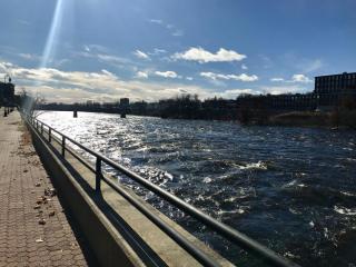
Watershed Management Plans
A watershed is defined as the geographic area in which all water running off the land drains to a given stream, lake, wetland, or other water body. Watershed management plans focus specifically on the watershed as a management unit. The watershed scale is preferred for assessment studies, stream classification and management planning for several reasons. First, the influence of impervious cover on hydrology, water quality and biodiversity is readily apparent at the watershed level. Second, watersheds are small enough to identify pollutant sources (e.g. storm water runoff, point sources, etc.) and develop clear management solutions. Moreover, since watersheds often cross municipal boundaries, it is necessary to build partnerships among communities to develop effective watershed management tools. For more information about the development of watershed management plans, visit the Center for Watershed Protection and the NH Department of Environmental Services Watershed Management Bureau websites.
Wellhead Protection Programs
The purpose of a wellhead protection program is to prevent well contamination. Once a well becomes contaminated, it is very costly and sometimes impossible to correct. Preventing contamination is important because most communities depend upon groundwater sources. Wellhead protection programs for new production wells are required by the State of New Hampshire. A community water supplier or municipality that is siting a new production well must develop a wellhead protection program for the well, which identifies the land area that provides water to the well and establishes a management program consisting of local health and land use regulations designed to prevent groundwater contamination.
Aquifer Protection Ordinances
An aquifer is any geologic formation that can transmit significant quantities of water to wells and springs. The term is used to describe both unconsolidated sediments and the underlying bedrock. Any formation containing a layer or zone which is relatively permeable (i.e. able to transmit water with relative ease), which is saturated (i.e. filled to capacity with water), and lies adjacent to a less permeable material can be considered an aquifer. In recent years, the US Geological Survey and NH DES have prepared a set of maps showing the extent of stratified (sand and gravel) aquifers throughout the state with the estimated transmissivity or ability of the aquifer to produce water. Many communities have adopted groundwater or aquifer protection regulations as part of their Zoning Ordinance, pursuant to RSA 674:16-21 Innovative Land Use Controls, in order to protect these valuable resources. A number of model ordinances exist and SNHPC provides assistance to communities in the development of these regulations.
SNHPC is providing assistance to the Ground Water Protection Council (GWPC) and New Hampshire Demonstration Project: Local Source Water Protection Measures.