Vulnerability Assessment
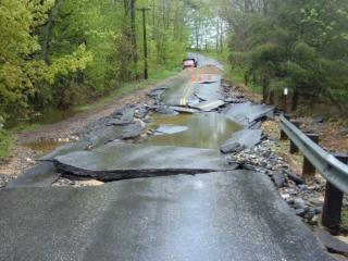
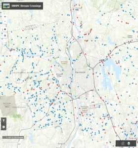
In 2018, SNHPC set out to analyze climate risks to the road network due to inland flooding, with a particular focus on the risks to culverts and small bridges, also known as stream crossings. The process, known as a vulnerability assessment, was designed to systematically evaluate around 1,600 stream crossings in the region.
A working group developed a scoring system for prioritizing stream crossings based on site sensitivity as well as the magnitude of risk related to failure. Key deliverables emerging from this effort include a Regional Vulnerability Assessment report (adopted 2020) and an interactive GIS map of stream crossings.
The vulnerability assessment provides local communities and regional agencies with decision-making tools to help them identify the highest-risk stream crossing locations to target for adaptation and hazard mitigation efforts. It also establishes foundational data that informed the development of SNHPC’s Roadway Adaptation Toolkit (2023).
For more information on SNHPC’s stream crossing analysis, contact Zachary Swick, Senior GIS Analyst, at zswick@snhpc.org.
Download Vulnerability Assessment View GIS Stream Crossing Map